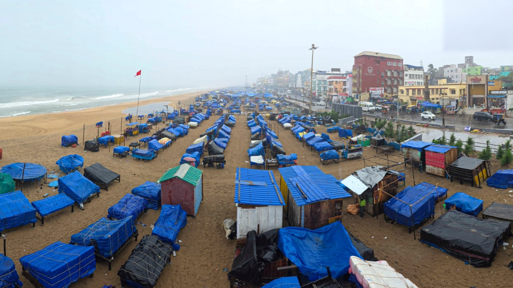
Cyclone Akvan began making landfall on the north Andhra Pradesh–south Odisha coast near Gopalpur in Ganjam district on Friday morning, November 20. The India Meteorological Department (IMD) downgraded it to a cyclonic storm that morning and expected winds of 70-80 kmph, gusting to 90 kmph, as it crossed the coast.
Akvan is the third cyclone to strike India’s east coast since late October. Cyclone Arnab crossed the Andhra Pradesh coast near Yanam on October 28 as a very severe cyclonic storm. Cyclone Murasu came ashore near Ongole on November 3 with winds of 100-110 kmph. Three systems have now hit the Andhra Pradesh and Odisha coasts in less than four weeks.
That quick succession may look exceptional. It is not uncommon for the Bay of Bengal at this time of year. November is the busiest month for cyclones in the north Indian Ocean, a product of how the southwest monsoon changes the atmosphere over the Bay through the year.
What a cyclone needs
IMD lists six conditions that a cyclone needs to form. The sea surface must be at least 26.5°C, and the warm water must extend around 50 metres down, because a cyclone runs on heat drawn from the ocean. The air above must be unstable enough for thunderclouds to build and moist at a height of about 5 km. The system must form at least 500 km from the equator, where the Earth’s rotation is strong enough to set it spinning. It needs a weak low-pressure system to grow from.
The sixth condition concerns wind shear. The wind at about 1.5 km and the wind at about 12 km must not differ by more than roughly 10 metres a second. Meteorologists call this difference vertical wind shear. When it is strong, it tilts a developing storm and pulls the column of cloud away from its centre. IMD says these conditions are necessary but do not guarantee a cyclone, since many systems that appear to meet them never develop. A cyclone season is the part of the year when they most often occur together.
Two peaks, with the monsoon in between
In most of the world’s cyclone regions, including the north Atlantic and the western Pacific, activity builds to a single peak in late summer. The Bay of Bengal and the Arabian Sea have two. IMD says cyclones in the north Indian Ocean peak in November, with a smaller peak in May. The Bay of Bengal produces about four cyclones for every one in the Arabian Sea.
The southwest monsoon falls between the two peaks. From June to September, IMD says, strong westerly winds blow below about 5 km while very strong easterly winds blow above about 9 km, and the shear between them breaks up storms before they can organise. The zone where systems form also moves to the north of the Bay during these months. Depressions that form there along the monsoon trough cross the Odisha and West Bengal coast within a day or two, too soon to gain much strength.
The sea stays warm through the monsoon and the air is humid, and both favour cyclones. In a 2013 study in the Journal of Climate, researchers from China, the US, India and Malaysia found that shear by itself cannot cancel those advantages. In their analysis, it took shear acting together with weaker spin in the lower atmosphere and a slightly less favourable ocean to suppress cyclones in summer.
The researchers also found that the two peaks have different causes. In April and May, the main change is a sharp rise in moisture in the middle atmosphere as the monsoon approaches. That accounted for 87% of the improvement in conditions for cyclones, measured by an index scientists use to rate how favourable the environment is. In October and November, the main change is the drop in the monsoon’s wind shear, which accounted for 91% of the improvement. By December and January, the drier air of the northeast monsoon closes the season.
October and November produce more cyclones than April and May because the air is more moist after the monsoon than before it, the study found. But between 1981 and 2009, the spring season produced more of the strongest storms, of Category 4 strength and above. The authors linked this to greater heat stored in the upper ocean at that time of year, and to stronger swings in tropical rainfall around the monsoon’s onset.
Storms shift south as the season goes on
IMD’s records show that Bay of Bengal cyclones most often strike the Odisha–West Bengal coast in October, the Andhra Pradesh coast in November and the Tamil Nadu coast in December. Tamil Nadu’s cyclone risk is therefore concentrated at the end of the year. Arnab, Murasu and Akvan all made for Andhra Pradesh and south Odisha, broadly in line with the usual pattern for late October and November.
The human response has also followed that pattern. Odisha evacuated nearly 300,000 people because of Cyclone Akvan. The concentration of landfalls in a few weeks puts repeated pressure on the same stretch of coast, even when each individual storm is forecast well in advance.
Why the Bay outpaces the Arabian Sea
IMD gives three reasons why the Bay of Bengal gets more cyclones than the Arabian Sea. Some Bay of Bengal cyclones begin as typhoons in the northwest Pacific, the world’s most active cyclone region, and cross the South China Sea into Indian waters. The Arabian Sea’s equivalent supply is storms from the Bay that cross the peninsula, and most of them weaken over land after landfall. The Arabian Sea is also cooler.
The Bay has another feature that makes a difference after the monsoon. Rivers and monsoon rain pour fresh water into it, and this lighter layer floats on the saltier sea below. When a cyclone passes, its winds usually stir up colder water from beneath the surface, which cuts off some of the storm’s fuel.
In a 2008 study, researchers at the Indian Institute of Science found that even strong post-monsoon cyclones did not cool the open north Bay, because the stirring reached only as far as a warm layer trapped beneath the fresh water. A 2012 study found that surface cooling under cyclones in the Bay is about three times greater before the monsoon than after it.
Why cyclones cluster
Cyclones often form in clusters. Researchers at the University of Hawaii reported in 2010 that about 60% of north Indian Ocean cyclones form during large swings in tropical rainfall that move across the region over several weeks. The best known of these is the Madden-Julian Oscillation, a band of cloud and rain that travels east around the tropics. The researchers found that it mainly influences cyclone formation in November and December, though a second pattern, which moves northward across the Indian Ocean, accounts for more cyclones overall.
That clustering helps explain why a coastline can go from quiet to three landfalls in quick succession. The seasonal window raises the odds, and shorter-lived patterns within it can bunch storms together rather than spread them evenly across the month.
The Atlantic comparison
The Atlantic hurricane season, which the US National Oceanic and Atmospheric Administration (NOAA) defines as June 1 to November 30, is the closest familiar benchmark for many readers. NOAA’s Hurricane Research Division says the dates were chosen because they cover more than 97% of tropical storm activity in the basin, and hurricanes do occur outside them. When the US Weather Bureau set up its hurricane warning network in 1935, it ran a dedicated telegraph line between its centres from June 15 to November 15. The current dates have been in place since 1965.
Activity within the Atlantic season is concentrated. A 1993 analysis used by NOAA found that August, September and October account for 78% of tropical storm days and 96% of the days with major hurricanes, and activity peaks in early to mid-September.
The Atlantic does not have an equivalent of the southwest monsoon to break up its summer. The 2013 study found that over the Atlantic, wind shear and humidity rise and fall together through the year. Over the Bay of Bengal, the summer shear for most of the season exceeds the highest level at which cyclones formed there between 1981 and 2009. NOAA also tracks a layer of hot, dry, dusty air from the Sahara that can suppress Atlantic storms during the warmer months.
The El Niño puzzle
This year’s run in the Bay of Bengal has come during a strong El Niño, a periodic warming of the central and eastern Pacific Ocean, thousands of kilometres east of India. NOAA’s Climate Prediction Center said on November 12 that El Niño was still strengthening and would likely stay strong to very strong through January-March 2027.
Warmer water gives a cyclone more energy, but mainly through the water that the storm passes over. The El Niño warming stays in the Pacific and reaches other oceans through the atmosphere. A warmer Pacific changes where air rises and sinks across the tropics, and that shifts winds, rainfall and ocean conditions far from the Pacific, including over the Atlantic and the Bay of Bengal.
Over the Atlantic, NOAA says, El Niño strengthens the wind shear that pulls storms apart. The 2026 Atlantic season has produced 10 named storms and one hurricane, against a long-term average of 14 and seven. If no other hurricane forms before November 30, it would be the first Atlantic season with only one hurricane since 1925, according to the US National Hurricane Center’s records.
Studies over recent decades have linked El Niño to weaker cyclone activity in the Bay of Bengal after the monsoon, though the link has varied over time. In a 2012 study in the Journal of Geophysical Research covering 1993 to 2010, M.S. Girishkumar and M. Ravichandran of the Indian National Centre for Ocean Information Services found that in El Niño years, the Bay during October-December had less spin in the lower atmosphere, fewer thunderstorms and less heat stored in its upper waters, all of which work against cyclones. La Niña years, when the Pacific cools, showed the opposite.
A 2015 follow-up by Girishkumar and colleagues in the journal Climate Dynamics found that the contrast depends on a slower Pacific cycle, the Pacific Decadal Oscillation, which changes phase over decades. During its warm phase, from 1975 to 2006, the Bay had more cyclones, and more intense ones, in La Niña years than in El Niño years. Other research has found that different types of El Niño affect the Bay in different ways.
This year, with an El Niño that NOAA gives about a 60% chance of becoming the strongest since 1950, the Bay has produced three cyclones in about three weeks. The run is a reminder that seasonal odds and shorter-term variability can pull in different directions. A strong El Niño may favour weaker Bay activity in some analyses, but it does not switch the season off.
What the season means
A cyclone season is a statistical window, not a wall. The conditions IMD lists are necessary but not sufficient, and the two-peak structure of the north Indian Ocean makes the Bay of Bengal especially prone to bursts of activity in May and again in October and November. The three landfalls in under four weeks fit that pattern: Andhra Pradesh and south Odisha are the usual late-October and November target zone, while Tamil Nadu’s risk is concentrated later, in December.
The practical implication is that preparedness has to be sustained through the window rather than treated as a single event. Odisha’s evacuation of nearly 300,000 people ahead of Akvan shows the scale of response the season can demand. It also shows why forecasters and disaster managers watch not only individual storms but the longer patterns, from monsoon shear and ocean heat to El Niño, the Pacific Decadal Oscillation and the MJO, that can make one month unusually busy and the next quiet.